How to Read Place Names on a Regional Map
Learn how regional map place names distinguish towns, districts, landmarks, and language variants, so you can identify what each label actually refers to.
Is that name on the map a town, a district, or a landmark? Reading place names on a regional map starts with the label’s wording, typography, and context—not simply the point where the letters happen to sit. Those clues help you tell what is named and avoid mistaking a label for a precise boundary.
Read the label style
Begin with the legend and any notes about naming conventions. Mapmakers often use different type sizes, colors, or letter styles for settlements, physical features, and administrative areas. A large, upright name might mark a city, while spaced lettering could identify a range or region—but the map’s own key, not a general convention, decides what a style means.
Look at the words as well as the type. A name followed by “River,” “Bay,” or “County” gives a direct clue to the feature. A bare name can be less clear: it might refer to a town, a municipality, or a wider district. Check nearby labels and symbols for context, then consult the map’s source notes if the distinction matters.
Separate places from areas
A settlement and the administrative area around it can share a name without covering the same ground. A point symbol may mark a town center; a shaded polygon or boundary line may show the municipality or district. Treat these as different map objects unless the legend explicitly links them.
Text placement is designed for legibility. A name may be moved away from a road, river, or symbol, and long labels may stretch across the feature they identify. The lettering’s center is not a reliable way to locate an official border. Follow a boundary line or look for a separate boundary map when the extent of an area is important.
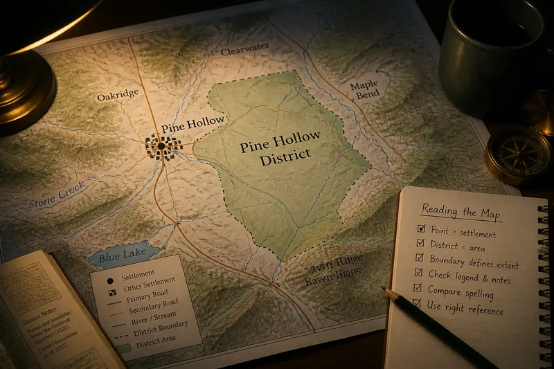
Say you are reading an invented regional map that labels “Pine Hollow” beside a dot and outlines “Pine Hollow District” with a pale fill. The dot indicates the settlement, while the outline marks the wider administrative area; the shared words connect their names, not their footprints. If you need to know which land falls within the district, use the outlined boundary rather than measuring from the settlement label.
Notice naming layers
Maps can show an official name alongside a local, historical, or alternate-language form. The preferred label may depend on the map’s purpose and the naming authority it follows. A smaller secondary name does not necessarily mean that it is less familiar to local residents; it may simply reflect the map’s editorial policy.
Keep spelling variants distinct from different places. Diacritics, transliterations, and older spellings can change between maps, especially across language boundaries or in places with a layered history. Compare the full name, feature type, and location before deciding that two labels refer to separate settlements.
For sensitive or contested names, check who issued the map and when. Naming practices can change, and different authorities may use different forms. A regional map can show what its publisher chose to print, but it may not explain the history or local preference behind that choice.
Check names in context
Use nearby features to test what a label refers to. A settlement name near a road junction and a cluster of building symbols likely identifies a community, while the same words placed along a river may identify the watercourse. The legend, symbol, and surrounding labels work together; none should carry the whole interpretation alone.
- If the label sits beside a settlement symbol, then treat it as a likely place-name and check the legend; if the symbol is unexplained, consult the map notes before assigning a type.
- If the name includes a feature word such as “Creek” or “Mountain,” then read it as a likely landform or water feature; if the map’s language is unfamiliar, check its naming key or source notes.
- If a boundary encloses the name, then distinguish the named area from any settlement inside it; if no boundary is drawn, do not infer the area’s extent from the text.
- If two labels share a name but use different type styles, then compare their symbols and wording; if the distinction remains unclear, seek a map that identifies administrative and settlement features separately.
- If spelling or accents differ between maps, then compare the feature type and location before treating them as different places; if those details conflict, check the publisher’s naming notes.
- If a name appears near a map edge, then check an adjoining sheet or locator inset for its wider context; if none is available, note that the map may show only part of the named area.
It is not worth trying to infer a settlement’s exact boundary from the width of its lettering or from the distance between words on the page. That effort creates false precision; the map’s outlines, symbols, and source notes are more useful evidence.
Which name questions matter?
Does a place-name label mark an exact location?
Not always. A point symbol may mark a center, but a longer label can be shifted for readability, so use the symbol or mapped feature rather than the text’s midpoint.
Can a town and district share a name?
Yes. Check whether the map uses a point for the settlement and a line or shaded area for the district; shared wording alone does not mean they have the same extent.
Why do maps spell a place differently?
Publishers may follow different official sources, languages, transliteration systems, or naming policies. Compare the location and feature type, then check the map’s notes before assuming that a spelling difference identifies a different place.
Where can you check an unfamiliar label?
Start with the legend, title, and source notes, then compare an authoritative gazetteer or local government map if the name’s identity matters. Use a source that matches the question: a gazetteer can clarify a name, while a boundary map is better for an area’s extent.
Choose the right reference
A regional map is useful for seeing how names sit among neighboring settlements and features, but it may simplify local distinctions or omit alternate names. A gazetteer can clarify spelling and feature type; an administrative map can show jurisdiction; a local map may include names that a regional sheet leaves out. Choose the reference that answers the specific question rather than expecting one map to settle every naming issue.
When a place name remains ambiguous, record exactly what the map shows: the printed form, nearby symbol, and any boundary or feature label. For place names on a regional map, that modest note keeps observation separate from assumption—and makes it easier to compare sources without confusing a name, a settlement, and the area around it.