Why Rivers Gather Towns at Their Crossings
Why rivers gather towns at their crossings: read the bridge, banks, approaches and nearby ground to see how a crossing draws movement into a place.
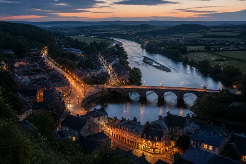
Why do towns cluster where a road meets a river? A river crossing gives travelers a reason to converge, but it does not settle the question of where a town can grow. Read the bridge, its approaches and the nearby ground together: the crossing gathers movement, while terrain decides where that movement can pause, spread and stay.
Follow the approaches
On a map, trace the roads toward the river rather than beginning with the town center. A bridge or ford may look like a single point, but its usefulness depends on the routes that feed it. Roads from farms, neighboring settlements or a port can funnel toward the same narrow passage. Where those routes meet, travelers encounter one another and goods can change hands.
Look for a bend in a road, a junction just inland, or a long straight approach aimed at a bridge. These shapes hint that the crossing has organized travel beyond the riverbank itself. A road that ends at the water with no bridge, ferry or visible continuation may instead mark an abandoned route, a changed crossing or a barrier that still divides local movement.
The network can be lopsided. Perhaps firm, level ground brings roads easily to one bank, while steep slopes or wet ground keep the opposite side sparse. A town may then stretch along the convenient approach rather than form a neat circle around the bridge. The crossing still attracts movement, but the settlement’s outline records which direction was easier to reach.
Read the riverbanks
Not every point on a river offers a workable crossing. A narrow channel can shorten a bridge, yet a deep, swift current may make the banks difficult to reach. A broad river might have a shallow ford in one place and unstable marsh nearby. The best crossing is not necessarily the shortest line across; it is the place where both sides can be approached and left without too much trouble.
Notice the shape of the banks. Gentle slopes allow roads to descend and climb without abrupt turns. High banks may require a bridge with long ramps, while low, flood-prone ground can leave the landing muddy or periodically unusable. A crossing may therefore sit where the river narrows, but the town’s main street may occupy a nearby terrace that stays drier and offers room for buildings.
Waterways also change character along their course. A tributary joining the main river can bring another route and another set of travelers to the same vicinity. Yet the meeting of two rivers can create a wide, shifting junction rather than a convenient crossing. Check whether roads actually converge there, and whether the ground between the channels appears suitable for settlement, instead of assuming that every confluence is a town center.
Spot the usable ground
Look for small differences in elevation around the crossing. A modest rise above a floodplain can provide a dry place for shops, homes and storage without moving far from the road. On a topographic map, closely spaced contour lines signal steeper ground; broad, widely spaced contours can indicate gentler slopes, though local drainage still matters. On an aerial image, terraces, field edges and street patterns may make the higher ground easier to pick out.
Flat land is not automatically ideal. The river’s low margin may flood, while a hillside close by may be too steep or broken for streets. A settlement often occupies a compromise: near enough to serve the crossing, but set back from the most troublesome bank and placed where roads can connect to surrounding land. That offset explains why a bridge and a town’s oldest-looking cluster may not sit exactly on top of each other.
Nearby land use can offer clues about what the ground is suited to. Fields may occupy a broad, level floodplain; buildings may cluster on a slightly raised edge; wooded slopes may limit expansion on one side. Treat these as clues, not proof. Present land use can reflect later decisions, and older settlement patterns may be concealed by newer roads, levees or development.
Watch movement change
A crossing attracts more than people simply walking from one bank to the other. It can collect carts, livestock, local produce and travelers needing a place to wait or exchange goods. When several routes meet, services have a reason to appear near the approach: a market street, an inn, a loading area or workshops. Over time, the town may become a place people visit even when they are not crossing the river.
Still, a crossing does not draw every kind of movement in the same way. A ferry depends on landing places on both banks and may connect streets that do not line up directly. A ford favors a route that can reach a shallow, stable part of the river. A bridge can carry a more fixed road alignment, but its entrances may be constrained by slopes or built-up blocks. These differences can shape where traffic queues, where shops cluster and which street becomes the town’s main spine.
Imagine a small settlement where two country roads meet a river at a low, shallow reach. A ferry links the banks, while the nearest dry building ground lies on a rise a short walk inland. If a later bridge replaces the ferry, the main road may become busier, but the older shops could remain on the rise because that is where roads, homes and level building plots already meet. The visible result would be a busy bridge approach alongside a town center slightly removed from the water.
Separate crossing and center
Use the map’s street pattern to distinguish a crossing point from a civic or commercial center. A bridge may carry a straight arterial road through town, while a market square, station or municipal buildings sit on a side street. The first concentrates through-movement; the second gathers local activity. They can overlap, but the distinction helps explain why the busiest road is not always the best place to find the town’s central public space.
Street names and landmarks can sharpen the reading. “Bridge Street” or “Ferry Road” may preserve a route’s function, while a market square or church indicates another kind of gathering place. Names are clues rather than reliable records: roads can be renamed, bridges relocated and centers shifted. Confirm the pattern by checking where streets lead and how they connect to the river.
Also notice whether the crossing sits at the edge of the built-up area. A highway bridge may bypass the older town, leaving the historic crossing quiet. Conversely, a newer bridge can pull shops and housing toward a once-peripheral bank. Comparing an older map, if available, with a current one can reveal that movement’s center has shifted, without implying that the original crossing stopped mattering.
When does a crossing attract a town?
Does every bridge create a town?
No. A bridge helps people cross, but it needs useful routes and suitable nearby ground to support a settlement. If roads lead nowhere important or the banks are hard to reach, movement may pass through without producing a town.
Why is the town center away from the river?
The river edge may be steep, flood-prone or too narrow for buildings and streets. A nearby terrace or junction can offer safer, more usable space while remaining close enough to serve travelers.
Can a ferry crossing gather settlement?
Yes. Ferry landings can draw roads and services to both banks, especially where travelers need to wait or transfer goods. The resulting settlement may form on one side, on both, or at a nearby junction depending on access and ground conditions.
What should I check first on a map?
Trace roads to both banks, then compare the crossing with contours, river bends and the built-up area. This quick reading helps separate a convenient crossing from the places that offer room for a town to grow.
Keep the reading grounded
For a useful field note, record four observations: what approaches the water, how each bank rises or falls, where the built-up area sits, and whether another route joins nearby. A paper map and pencil are enough; a topographic map can add contours, while an aerial view can clarify streets and land cover. The aim is not to name a single cause, but to see how the crossing and its setting work together.
- Mark the bridge, ford or ferry landing, and note whether roads align across the river.
- Trace the main approach roads back to their junctions and nearby settlements.
- Compare the crossing with higher ground, steep slopes and visible floodplain.
- Locate the town’s densest street pattern, market area or public center.
- Check for a tributary, rail line or later bypass that may have redirected movement.
Do not spend time treating every street bend as evidence of an ancient route. A single curve can result from later construction, property lines or a changed road. Look for several clues pointing in the same direction before assigning a story to the settlement.
The reason rivers gather towns at their crossings is not simply that a bridge joins two banks. The crossing gives separate routes a shared point; the surrounding terrain determines whether travelers can reach it, wait nearby and build beyond it. On your next map, follow the roads to the water, then look one rise inland. That small gap between bridge and town may tell you as much as the crossing itself.